El Niño is already underway: new satellite data has emerged
Kyiv • UNN
In June 2026, the El Niño phenomenon returned, characterized by higher water temperatures in the Pacific Ocean. Data from the Sentinel-6 Michael Freilich satellite indicate a strengthening of the phenomenon, which could have consequences for weather in various regions.

The climate phenomenon El Niño, characterized by higher than usual water temperatures in parts of the equatorial Pacific Ocean, returned in June 2026. Sea surface height observations from the Sentinel-6 Michael Freilich satellite that month showed that the 2026 phenomenon continues to intensify, reports UNN citing Phys.org.
Details
This recurring natural phenomenon can have widespread consequences, typically leading to wetter conditions in the southwestern United States and drought in western Pacific countries such as Indonesia and Australia. The U.S. National Oceanic and Atmospheric Administration (NOAA) declared El Niño on June 11 after sea surface temperatures in the central and eastern equatorial Pacific exceeded the average by at least 0.5°C for several consecutive months.
Meanwhile, NASA scientists are observing an additional sign of El Niño: areas of elevated sea surface height. When ocean water heats up, it expands in volume and causes the sea surface to rise, making water height a reliable indicator of ocean temperature. Higher than normal temperatures, and therefore higher sea surface levels in parts of the equatorial Pacific, are associated with the El Niño phenomenon.
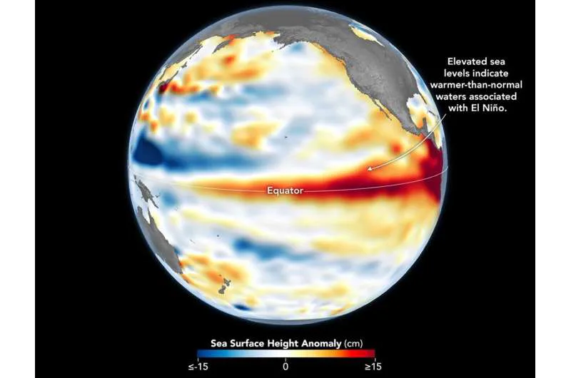
The map shows sea surface height anomalies in the central and eastern Pacific Ocean recorded on June 8, 2026. Red shades indicate sea levels above average. Normal sea levels are shown in white, lower levels in blue.
The data, as indicated, were obtained from the Sentinel-6 Michael Freilich satellite, launched in 2020 by NASA under the leadership of ESA (European Space Agency), and processed by scientists at NASA's Jet Propulsion Laboratory (JPL).
In the spring of 2026, the satellite began recording precursors of El Niño: waves of warm water hundreds of kilometers wide, known as Kelvin waves, moved from the western Pacific Ocean to the eastern. This occurs when the trade winds in the western equatorial Pacific weaken and then temporarily reverse direction to westerly. Warm water accumulates in the east, deepening the warm surface layer, lowering the thermocline, and suppressing upwelling, which normally maintains cooler water temperatures along the Pacific coast of the Americas, the publication writes.
This accumulation of heat beneath the water's surface is what sea surface height observations capture. It goes beyond measuring surface temperature and shows how much heat is stored in the subsurface layer. This is important because a shallow warm layer may not significantly affect climate and weather, while a large reservoir of heat beneath the surface can be more significant.
According to JPL sea level researcher Severin Fournier and Deputy Project Scientist for Sentinel-6 Michael Freilich, conditions in the western Pacific Ocean on June 8 were similar to those in 1997, when an exceptionally strong El Niño event occurred. However, in the eastern Pacific Ocean in 2026, a lag toward warm conditions was observed, and fewer Kelvin waves had formed by the same date.
Nevertheless, it appears that warmer Kelvin waves are approaching the eastern Pacific Ocean, meaning El Niño continues to intensify. Whether it will catch up to the 1997 levels depends on ocean activity in the coming weeks. "So far it looks like it will be a strong event — stronger than I would have said last week — but we still need more observations to understand what will happen," the researcher noted.
UN warns of new climate risks due to possible arrival of El Niño23.03.26, 07:14 • 7459 views